nostalgeo wins the audience award at Apps For Europe
After winning AppsforGeo and AppsforFlanders, nazka's nostalgeo also won the audience prize at Apps for Europe.
read more
12 february 2025
Maps are powerful tools that can drive positive change and contribute to a better world. Our slogan, "Creating maps that matter for society", reflects our commitment to developing mapping solutions that address real-world challenges. One way to illustrate this is by checking how our maps support the United Nations Sustainable Development Goals (SDGs).
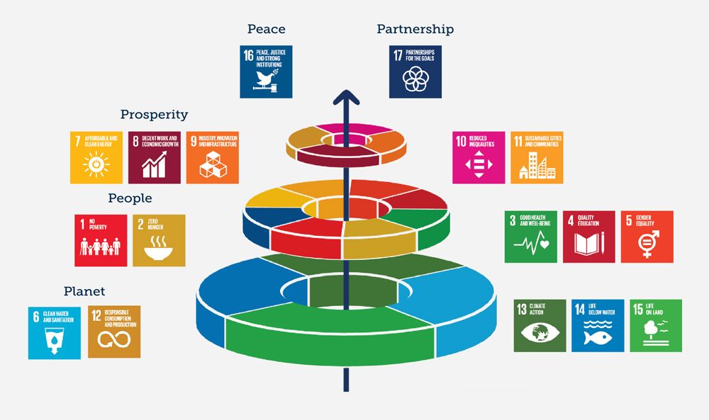
The Sustainable Development Goals (SDGs) are a universal call to action to achieve a better and more sustainable future for all by 2030. Adopted by the UN in 2015, the 17 goals address global challenges ranging from climate change and inequality to health and education. These goals are not isolated; they are interconnected and interdependent, working together to create a more sustainable and equitable world.
A helpful visual representation of this interconnectedness is the "SDG cake," which depicts the goals as layers of a cake, highlighting their integrated nature and the foundation they provide for one another. Understanding this interconnectedness is crucial for effective action towards achieving the SDGs.
The following examples highlight some of the projects we've undertaken, demonstrating our commitment to creating maps that matter for society and contribute to a more sustainable future.

Through our work with MOBVEC, we are contributing to the fight against vector-borne diseases . Our maps facilitate trap planning and data sharing from mobile lab operations. This supports efforts to improve disease surveillance, prevention, and control, directly contributing to the goal of ensuring healthy lives and promoting well-being for all.
Read more: This groundbreaking mobile lab can assist health authorities in containing outbreaks of mosquito-borne diseases

Many of our maps support renewable energy. On a global and European level, we're collaborating with Technical University of Denmark , The World Bank and many other partners for the Global Wind Atlas, the New European Wind Atlas and the WIMBY (Wind In My Backyard) project. More locally, we work closely together with Extraqt, a Leuven-based startup specialized in modeling energy extracted from surface waters like lakes and rivers to heat or cool buildings, to create interactive aquathermal maps. Our maps help visualize the potential, while also emphasizing the importance of careful management and respect for the environment.
Read more: Aquathermal energy in East Flanders: Look at the enormous potential, Harvesting energy from rivers in Colombia, The Global Wind Atlas, Wind In My Backyard

In partnership with Mobiel21, POM West-Vlaanderen, and VDAB (the public employment service of Flanders), we've developed naarjobs.be. This platform connects job vacancies with sustainable mobility options in real-time. By integrating location data and transportation information, naarjobs.be helps people find jobs that are not only a good fit for their skills but also accessible through environmentally friendly commuting methods, promoting both economic growth and sustainable practices.
Read more: NaarJobs: sustainable mobility is important in the search for a job

Together with Fietsberaad, we've created Velopark.be, a comprehensive platform that centralizes information about bicycle parking facilities across Belgium. Velopark.be empowers cities and municipalities to manage and share data about parking locations and quality, making this information readily available for integration into various applications like digital maps, route planners, and cycling apps. This contributes to creating more bike-friendly cities and encourages sustainable transportation.
Read more: All bicycle parking facilities in Belgium are on Velopark.be.

In collaboration with the remote sensing unit of VITO, we've developed EXPLORE, a satellite-based platform used to monitor water quality. Initially deployed in Vietnam, we are now adapting this system for environmental monitoring of Lake Tanganyika in Africa, with support from Flanders International Climate Action Programme. EXPLORE provides crucial data for understanding and protecting vital aquatic ecosystems, contributing to the preservation of life below water.
Read more: The power of earth observation: monitoring our environment with EXPLORE, Climate-resilient water management in Lake Tanganyika and Lake Kivu, East Africa
These examples showcase just a few ways Nazka Mapps is using the power of maps to address critical societal challenges and contribute to the achievement of the SDGs. We believe that maps can be a force for good, and we're committed to continuing our work in creating maps that matter for society!


